Click here to read about The Triple Divide
The trees that existed on the lands of Portville before white men
came through were 3 times the size they are now, and the forests were dense. The American Indians used the Twin
Tier region as a sacred hunting and fishing ground. Both the Iroquois and the Erie Nation fought with others to gain
control.
The first white man to visit this area was a soldier of fortune named Stephen Brole. In 1615, he made the
dangerous journey to Oil Spring in Cuba, but he did not record his adventure. He did urge Joseph de la Roche d'Allion,
a Franciscan frair, to visit the sacred spring, which bubbled up oil used by the natives from all over the region. He
arrived in 1627...the first time petroleum was seen on the American continent and historically recorded.
In 1643, the Iroquois removed the Neutral Nation out of the Niagara
Frontier...pushed west by the influx of Europeans. Their western border of the Genesee River was no longer sufficient.
In 1655, the Iroquois completely vanquished the Eries from the Southern
Tier region, pushing them southwest into Pennsylvania and Ohio.
Right after 1655, there was peace in Cattaraugus and Allegany Counties. The Senecas had four villages in
Catt County...all of them along the Allegheny River near what is now the State Park and Reservation.
The Forbidden Path, an exclusive Native American trail that extended across the Southern Tier, passed through
Ceres, Portville, and Olean well before those names came around. This great path connected the Senecas to the Susquehanna
region.
In Portville, the Indians used to dam up Dodge Creek at the sharp bend of Mayville, flooding the lowlands back
to Ubadam, thus attracting fish and game. This is also the exact spot where the four Dodge brothers put up their first
saw mill in the early 1800s.
Above the Dodge at that point, way beyond where the cemetary now exists, the steep 2,000-foot hill served as
a nice lookout for the Iroquois warriors...who could oversee the Allegheny River Valley, as well as up the Dodge and Deer
Creek.
After the American Revolution, which ended in 1782, migration into New York State accelerated. The
first white settler in Allegany County was Nathaniel Dyke, a Yale grad and member of George Washington's staff. He built
a settlement in Andover in 1795.
In 1796, another soldier, Moses Van Campen, settled in Almond. Moses had fought against the Iroquois,
but gained their respect when he survived a gauntlet after being captured.
The next closest neighbor in the area was Francis King, who settled in Ceres, PA in 1797. King was
a Quaker from London, then Philadelphia. In 1798, three missionary friends of his temporarily settled among the Senecas
in Catt County.
Benjamin Van Campen, Moses' nephew, was the first white man to explore the Portville area. Employed
by Major Adam Hoops, he trekked from the Van Campen Settlement in Almond to the Dyke place in Andover, starting in November
of 1802.. Alone and with one compass, he walked to the King Settlement and set up a base camp.
He followed the Oswayo Creek to the Allegheny, hiked through Portville and ended up in Olean, noting that
it would be the best place to build a home. He also noted the oil on what was later named Oil Creek at the location.
The journey took Benjamin two months, and Major Hoops bought the property in January of 1803. That
summer, Hoops and David Hueston became the first residents of Hamilton, which was later changed to Olean.
The main event that initiated movement into the Portville area was
the 1797 Treaty at Big Tree (Geneseo). At that historic and infamous meeting, New York bought the Western NY region
from the Iroquois Confederacy for $100,000 and established a number of reservations. Indian Chiefs Red Jacket and Cornplanter
were instrumental players at the gathering of leaders.
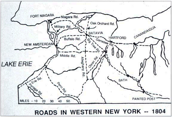
A group of Dutch businessmen called the Holland Land Company purchased Western NY and
began the arduous task of exploring and surveying the wilderness. Within a short time, main roads were built throughout
the region, as shown below.

|
| Click picture for story on Early Roads |
View Larger Map
 |